
Day 11: Bears Ears National Monument, Natural Bridges National Monument and Monument Valley
📍Bears Ears National Monument: The historic Bears Ears Inter-Tribal Coalition, composed of representatives from the Hopi Tribe, Navajo Nation, Ute Mountain Ute Tribe, Ute Indian Tribe of the Uintah and Ouray Reservation and the Pueblo of Zuni, was formed to protect and defend the sacred land around Bears Ears. The Zuni and other southwestern Pueblo tribes, such as the Hopi, are descendants of the Ancestral Puebloans, who inhabited the canyons and mesas of the Bears Ears region of southern Utah before migrating away in the late 13th century.
Bears Ears National Monument is a United States national monument located in San Juan County in southeastern Utah, established by President Barack Obama by presidential proclamation on December 28, 2016.
Before heading into Bears Ears, make sure you stop in at the Visitors Center in Blanding, Utah. They are a wealth of information regarding permits for day use and you will need off-road maps to help you navigate to the trailhead that takes you to the “House of Fire”. Be aware that Bears Ears is remote and undeveloped. Plan ahead!
We left the Visitors Center and away we went.
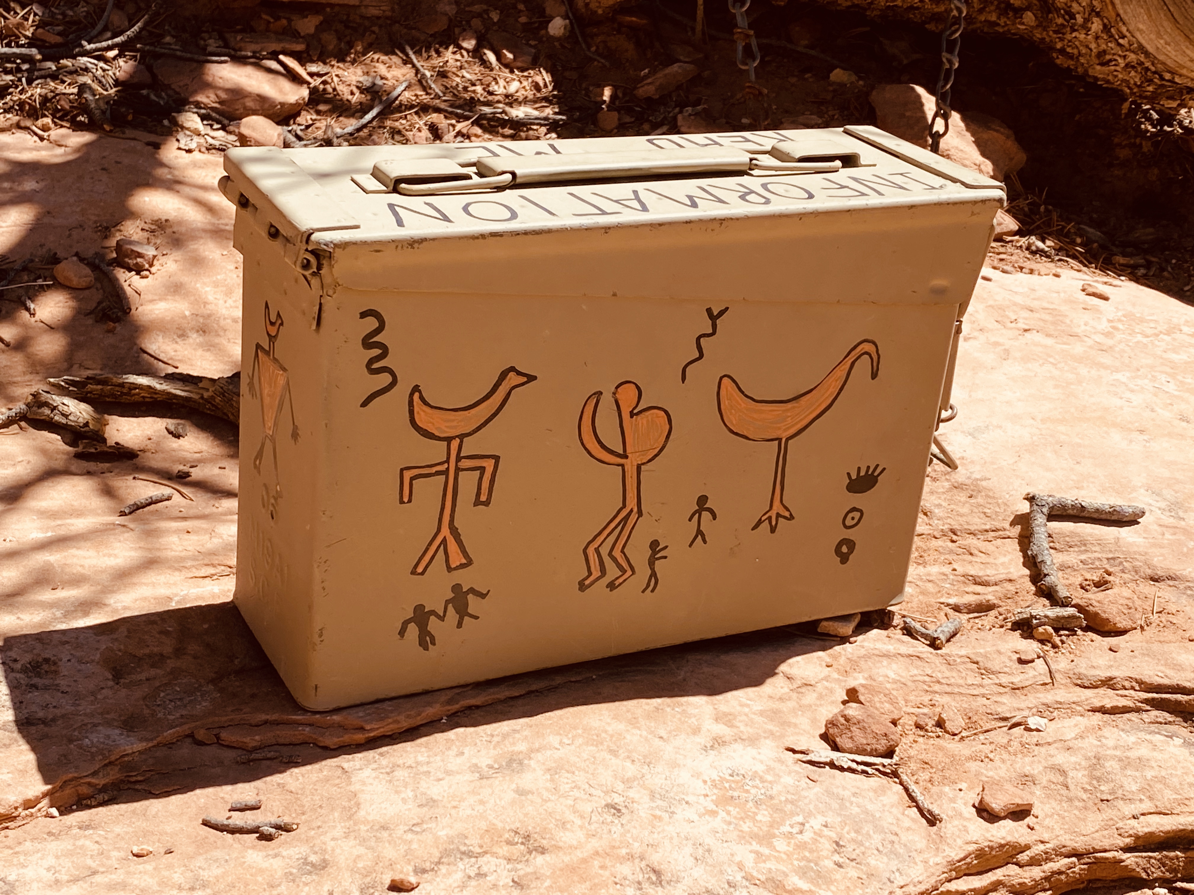
Do NOT follow your GPS to Bear Ears National Monument. Even though the hike to House of Fire is in Bears Ears, you actually find the trailhead off Highway 95, between mile markers 101 and 102. Yes, mile markers, because there are no signs. There is a dirt road with a cattle crossing; turn right. Past the cattle crossing is where we bought our permit, $5.00 per person. We grabbed an envelope from the metal box, added our car details and money and slide the envelope through the slot.
We continued 1/4 mile down the dirt road; does this sound sketchy to anyone else yet? Yah it did to me too, and we almost turned around, but this adventure intrigued us. I kept having visions of blowing a tire on the rental car and getting stuck out there, in the middle of nowhere, no cell service and 95 F degrees. We only knew where the trailhead was because there were two other cars parked there, that were leaving. That was comforting, sort of. One of the hikers told us to follow the river bed, which follows the trail from below and there is less bush whacking to do.
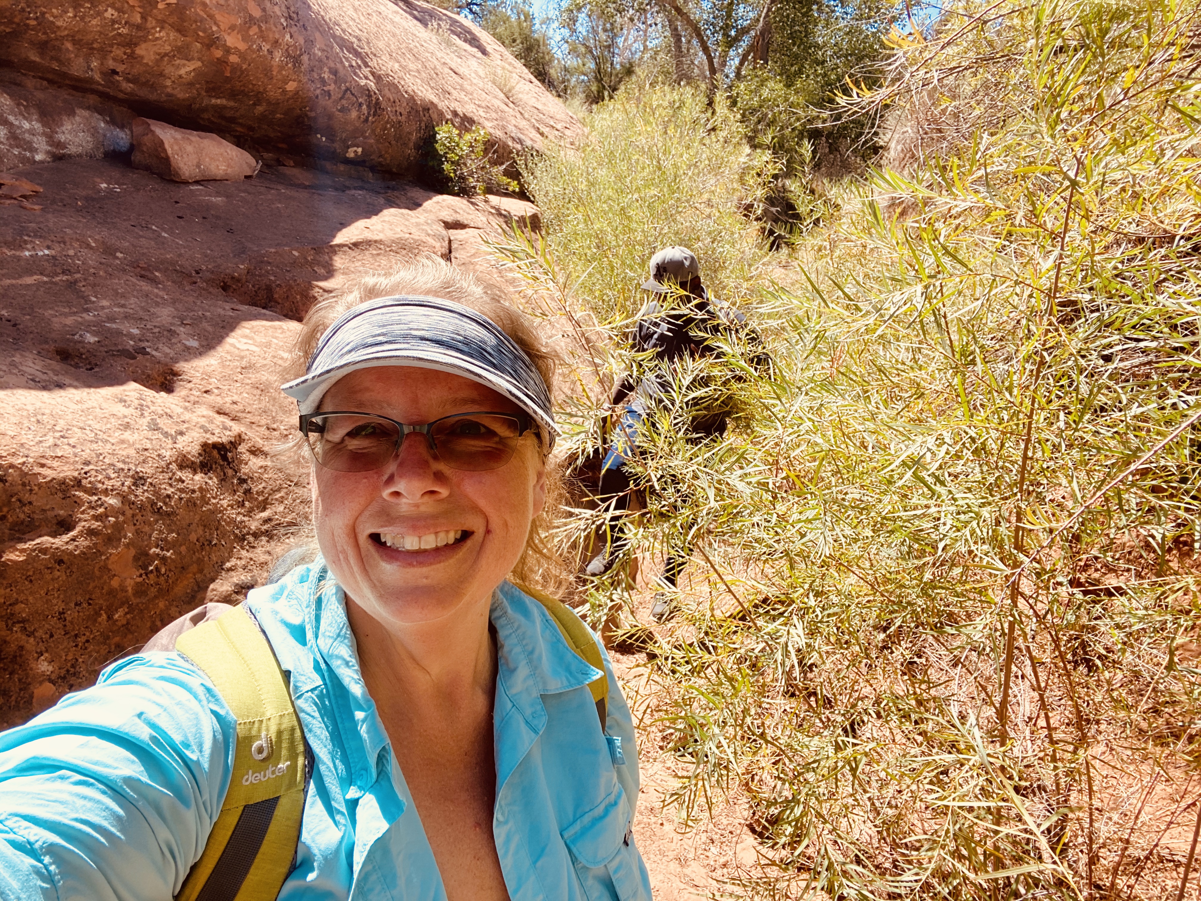
We got all of our gear (backpacks, trail runners, water and snacks) and walked down the road and found a trail marker, and the sign-in log for backcountry hiking. This is to make sure all who go in, come back out. 😳 We signed our names and headed in. I will be honest, this was completely out of my comfort zone, 110%! Unsure where we were headed, in the mid-day heat, and with no one else in sight. I packed in 2 liters of water, and you will need it! Don’t take any less on a hot day. This trail is a little over 3 miles roundtrip.
We started on our way, saw the section to take the dry river bed instead of the trail, and headed that way. However, we must have turned down the riverbed too soon, because it became impassable. So much so, I got a gouge in my calf from a dry branch, a good puncture hole. At this point I was thinking, “ok that’s it, I’m done, let’s go”, so we turned around, hiked back up the riverbed, and Ken found an alternative route. Okay fine! We went right, instead of left back to the car, and I am SO thankful I didn’t give up! 😘
This trail is fairly easy, just long and exposed to the sun for 90% of the way. It wraps back and forth over the riverbed, across slick stone, under tree limbs and through brush. Some of the brush was extremely sharp, so you had to sort of run through it, otherwise the prongs from the plant would go right through your pant leg, and that was not pleasant, trust me!
We didn’t see a soul on the trail, which was lovely and sort of creepy. The landscape here is immense, and easily makes you feel minuscule. Hawks and ravens flew above us, and many lizards scurried at our feet.
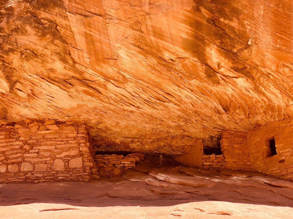
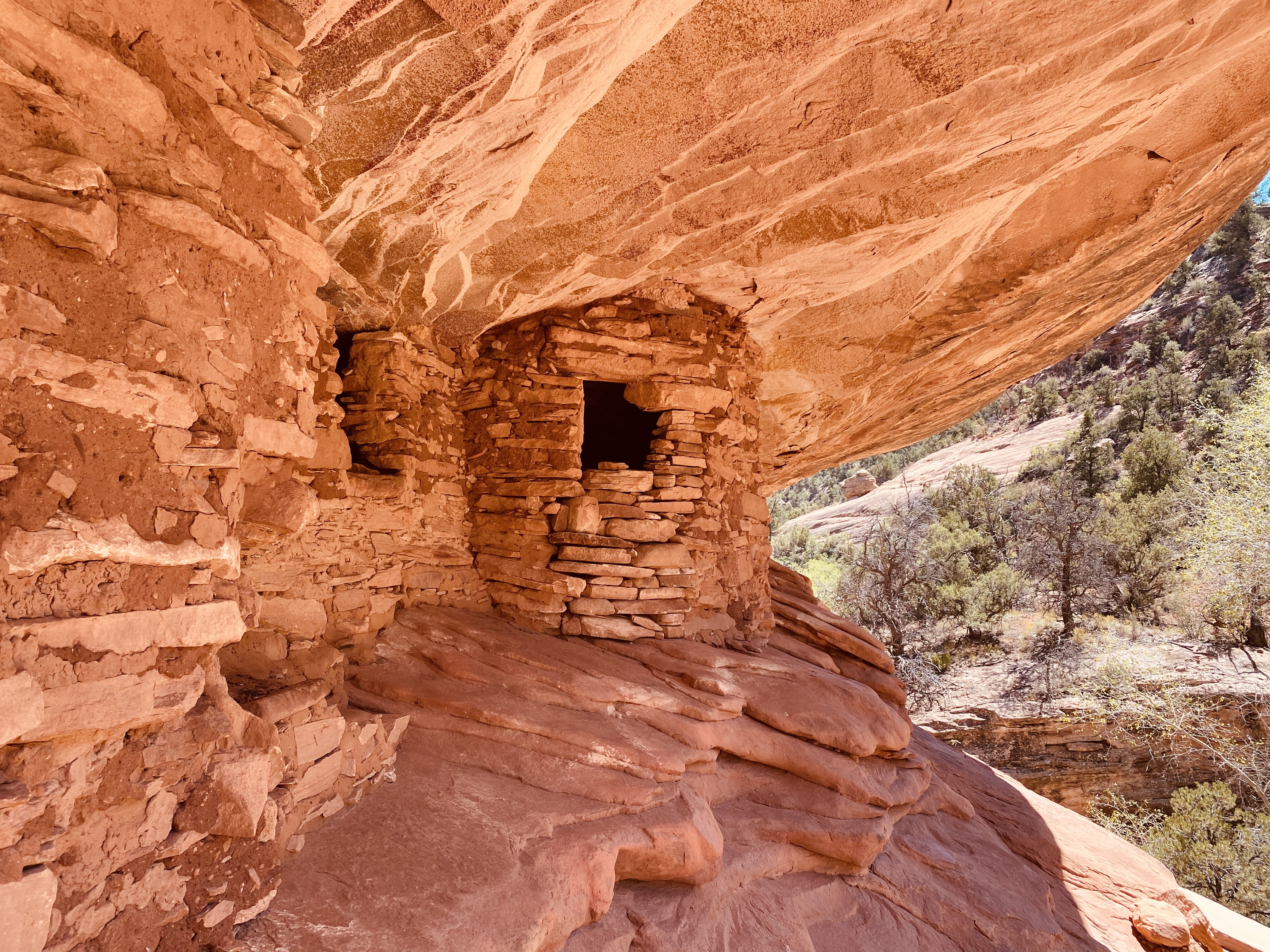
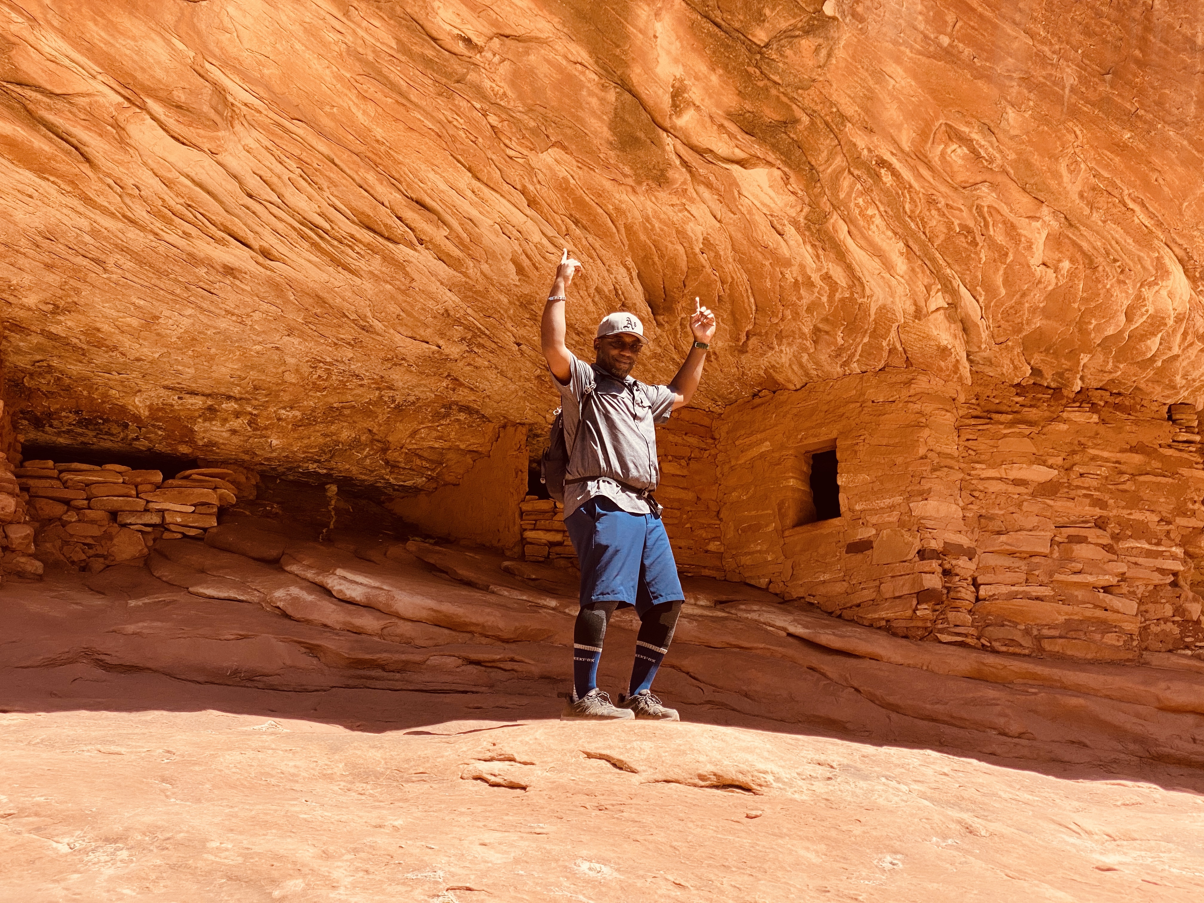
We made it to The House of Fire; and we had it all to ourselves, despite it being a holiday weekend. This site is well preserved and consists of 5 granaries built into cedar mesa sandstone. The rock overhang forms the ceiling and has a streak pattern that mimics flames, hence the name. The Puebloans lived here between 700 and 2,500 years ago. These granaries perched high in the cliffs stored corn, a main food source. The Puebloans also ate prickly pear, which is abundant here. The yucca you see when hiking was spun into fibers to make baskets, sandals and bags. At the foot of the granary was a metal latched box, which contained a check in notebook and information about the area. We stayed here for awhile to sit in peace, and take comfort in the shade under the cedar mesa sandstone ledge. Every now and again the wind would blow through making a whispering whistle sound through the canyon. We felt very fortunate to have had this place to hike to, and were thankful it could be shared.
By the time we climbed out of the canyon, it was 102 F degrees. I drank 4 liters of water today and anyone who knows me, knows that has never happened in my lifetime. Never ever!
Once back at the car, we had some fruit, drank more water and ate some beef jerky. As lovely as this hike was (and I would do it again in a heartbeat), I was also glad to be driving back to a paved road!
From here we drove onto Natural Bridges National Monument. This monument actually had a visitors center, gift shop and water refill station. We filled up! Natural Bridges became a natural monument in 1908.
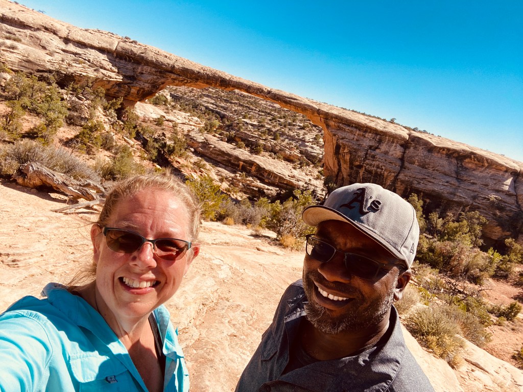
This is a 9 mile one-way loop drive, but also a walkable 8.5 miles on trails that zigzag through the area. It features 3 bridges, named “Sipapu”, “Kachina” and the oldest bridge of the park “Owachomo” in honor of the ancestral Puebloans who once made this area their home. The first bridge is Sipapu and there is a moderate 1.2 mile hike down to the bridge, if you have time, but you can also see the bridge from the viewing deck, which is what we decided to do. The second bridge on the driving loop is Kachina. It’s also a short walk down to a viewing deck, however, it wasn’t as impressive and a bit hard to spot where the bridge was. I kept looking into the landscape and eventually saw it. The last and final stop was at the Owachomo bridge. We walked out to the viewing deck, but really wanted to get a closer look, so we hiked the trail down, down, down, and got a beautiful view of this bridge. We highly recommend you take the hike; it’s worth it no matter how tired you might be.
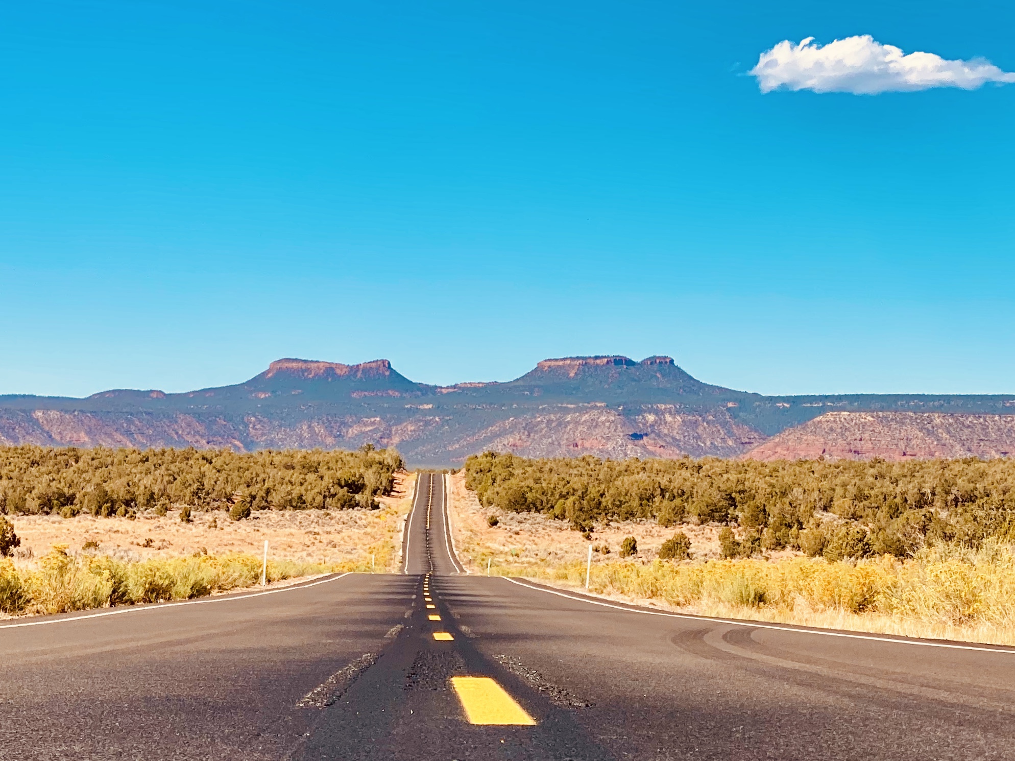
We headed back to the visitors center, refilled our water bottles again and headed to our last pitstop for the day; Monument Valley. Part of the road to Monument Valley has an interesting story. Once you leave Natural Bridges, you head back out on Highway 95 to Highway 261. This highway has not been completed, and probably won’t be. There is a 3 mile portion which winds down the other side of the mountain that is a two way gravel road with a rock wall on one side and shear cliffs on the other. Apparently this road used to be paved, however in the extreme heat, the asphalt melted. Yah, melted! So they dug it all back up and kept it a gravel road. Take your time and use extreme caution on this road. The views below are amazing, if you have the stomach to look over the edge.
Once at the bottom, our temperature gauge in the car hit 104 F at 4:50pm. We made our way to Highway 163. This is a very famous stretch of Highway. We stopped at mile marker 13, which is the exact point, in the movie Forrest Gump where he decides to stop running and turn around. He had run 3 years, 2 months, 14 days and 16 hours. We love that movie!!
Driving into Monument Valley is like driving onto a fake movie set. The main reason I wanted to stop here was strictly for the landscape. It has been the backdrop for so many western movies.
📍Monument Valley: The valley lies within the territory of the Navajo Nation Reservation.The valley’s vivid red color comes from iron oxide exposed in the weathered siltstone. The darker, blue-gray rocks in The Valley get their color from manganese oxide. It’s the site of one of the most iconic photos of the American West.
We checked into our room at Goulding’s Trading Post and Lodge. It is the only place open right now in the area due to Covid. Monument Valley National Park is also closed. We will come back one day when the world resumes to normal.
The room has a 1970’s vibe and oddly it smelled like my Grandma’s house, in a good way. It made me instantly happy and comforted for some reason. It’s amazing how a smell can take your brain right back to a specific time in your life. I’m not even sure what makes this “smell”, but it’s homey.
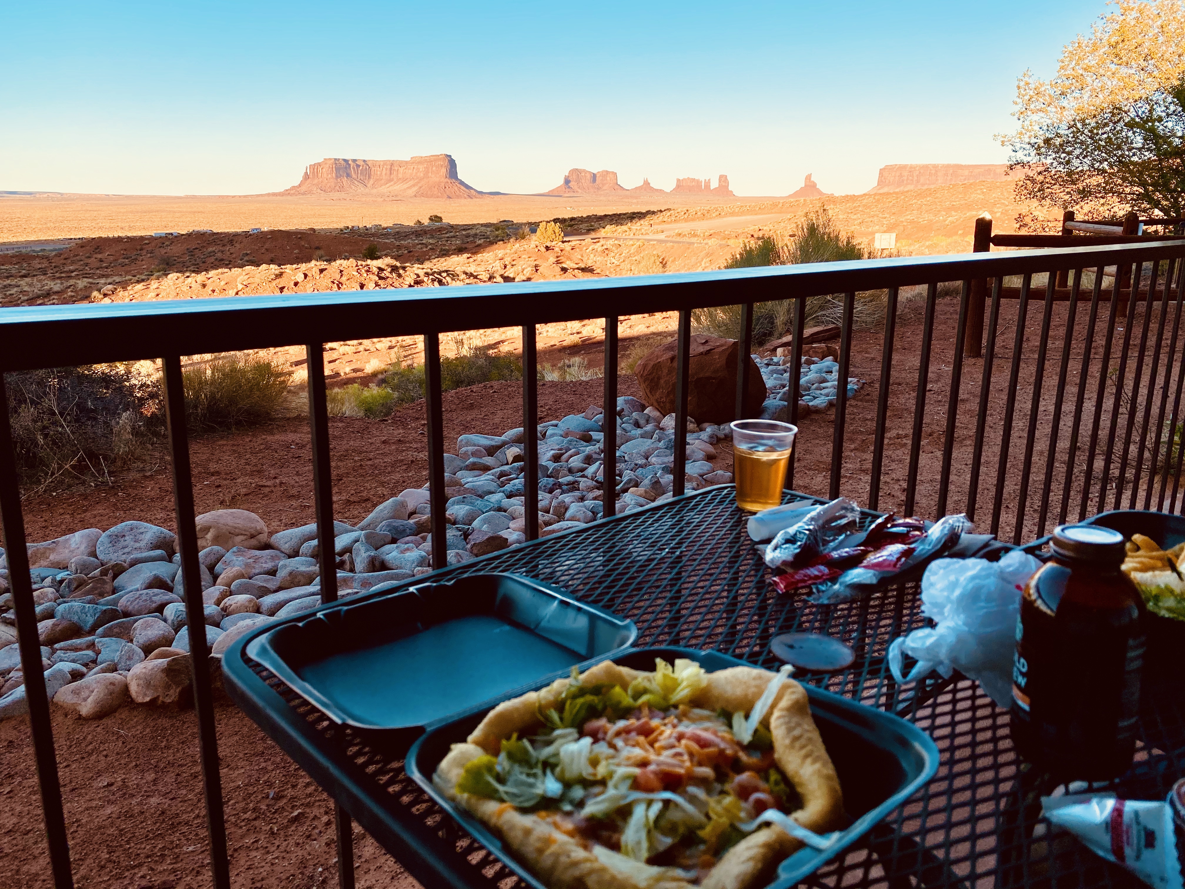
It’s dinner time and we haven’t had much today because a few nibbles here and there. The restaurant at the lodge was offering take-out only and served the basic American fare, but they also made authentic Navajo Fry Bread Tacos! I’ve been looking for these beauties since we hit Southern Utah. I’m one happy chick!
We ate dinner on the patio of our room and watched the sunset throw shadows on the giant monuments in the valley. Seriously, magical! Nighty night!
Note: If you have any questions about any of the places we’ve been, feel free to send us a message. I’ve mapped out an entire itinerary.
A cool 85 degrees.

So what a wonderful trip it’s been. Might do without the heat, many places I remember many years ago. Oh the fry bread , also made by a little Peruvian lady in Peru. It’s like the best bread I have ever tasted.
LikeLiked by 1 person